Seven Dragons Across Asia
A dream that became an adventure! 
By Bill Pratt
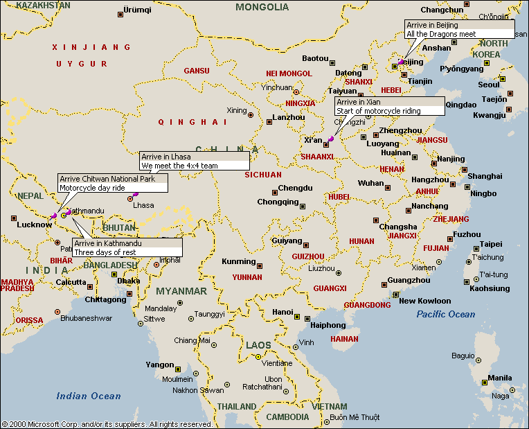
The Dragons Route:
China-Tibet-Nepal - Map of Asia
|
|||||
|
|
|||||
|
|
|
|||
A
relief map would have shown the elevation of the expedition route
from Beijing to Kathmandu. We traveled
from sea level to over 17,200 feet. The
team ascended over 17,000 feet more than four times during the course of a
week. Our stay at 16,400 feet for 48
hours while visiting the base camp area of Mt. Everest made for some really
weird dreams. With proper preparation
and gradual adjustment to the change in elevation, the entire  team
avoided the effects of altitude sickness.
The combination of daily doses of Diamox and aspirin with three liters
or more of water helped alleviate any symptoms that could terminate the
ride. Once you have altitude sickness,
going to a lower elevation usually remedies the effects. In the worst of cases, total evacuation and
medical treatment could be in order. We
were very lucky to avoid these problems.
team
avoided the effects of altitude sickness.
The combination of daily doses of Diamox and aspirin with three liters
or more of water helped alleviate any symptoms that could terminate the
ride. Once you have altitude sickness,
going to a lower elevation usually remedies the effects. In the worst of cases, total evacuation and
medical treatment could be in order. We
were very lucky to avoid these problems.
Ken brought along his handy Garmin emap GPS receiver. He mounted the unit on his handlebars and recorded the entire route. The recordings include longitude, latitude, elevation and direction. Those readings were then imported to Garmin’s MapSource mapping program where an accurate route map was created…see map#2. Thanks to Ken’s Motorola friends for giving him this great device as a going away present.
As it turned out, the GPS receiver helped determine if we were on the correct roads, approximate distance to our next stop and how many hours would be required to make our destination. Many times during the day, I would walk by Ken’s KLR650 and peak at the GPS to check our elevation. With the push of a button you could see the actual route map and pinpoint your location to within 20 feet.
![]()
![]()
![]()
Ó Copyright, Bill Pratt, Mill
Creek, WA – March 2001